FIG Foundation - Building a Sustainable Future

|
Research Trip 2014 - Report by Simon Hull
Germany and the Netherlands
Thanks to sponsorship received from the FIG Foundation I was able to
conduct a research trip to the Netherlands and Germany during September and
October 2014. The purpose of the trip was to learn as much as possible about
the cadastral systems of the two countries. These two cases are the first to
be studied as part of a multiple case study towards my PhD. I plan to follow
up with several cases from southern Africa in 2015.
The topic of my PhD is cadastral development, specifically with the aim
of assessing the impact of development on the general citizens of a nation /
state. Hence the interviews I conducted were with the aim of understanding
the state of development of the German and Dutch cadastres, and how they got
to their current respective states.
This will form the basis for comparison with developing cadastres in the
southern African context. I went first to Stuttgart where I met with Marcus
Wandinger, secretary-general of the AdV1),
and Günther Steudle, the principle officer of surveying and geoinformation
at the Ministry of Rural Affairs and Consumer Protection, Baden-Württemberg.
I later met with Jens Riecken in his office in Bonn, North-Rhine Westphalia.
He is the vice-president of the DVW, Cologne District Government, and head
of the department of cadastral surveying and geodetic reference. These key
informants gave me most of the information I needed regarding the origins
and development of the German cadastre, with specific attention to the
current ALKIS® project which should see completion across all states by the
end of 2015. This is an important project in Germany and is an interesting
case of cadastral development. The project hinges around the amalgamation of
the cadastral map (ALK) and cadastral register (ALB) into a joint system,
ALKIS®. The AdV is also involved in the integration of ALKIS® (the real
estate cadastral information system), AFIS® (the authoritative control point
system), and ATKIS® (the topographic information system) into a common
application scheme called the AAA® model. What makes the ALKIS® project
unique is that, in Germany, cadastral surveying is the responsibility of
each state. Hence cadastral development has needed to take into account the
different needs and procedures of all the different states, resulting in a
weighty document (the GeoInfoDoc) of standardised procedures for all states
to follow. Of particular interest for my research was learning how the
opinions and needs of relevant stakeholders were included in the new
development, and how the success of the project is measured.
After Bonn I moved to Apeldoorn, Netherlands, where I spent a week at the
office of Kadaster. They arranged a full program for me to get a feel for
the various improvements that are being made to the Dutch cadastre on an
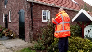
on-going basis. I got a chance to spend a day with a surveyor in Zwolle,
observing first-hand how cadastral surveying is done in the Netherlands. I
was quite surprised at how different their approach is to the South African
approach. During the rest of the week I met with several people: Co Meijer,
Marije Louwsma, Dan Liu, Gerard Leenders, Jacques Vos, Bob Bakker, Alex de
Jonge, and Magdalena Grus. Each of these people took time out of their busy
schedules to explain a specific project within Kadaster with which they were
/ are involved. I discovered, for the first time, the concept of a negative
cadastre (i.e. subdivision and sale of new portions prior to cadastral
surveying). With each of the projects described to me, I was again
interested to learn how the opinions and needs of stakeholders had been
accommodated and how the project’s success was / is being measured. I was
also particularly interested in Co Meijer’s account of the work done by the
international office of Kadaster, especially into Africa.
1)
Arbeitsgemeinschaft der Vermessungsverwaltungen der Länder der
Bundesrepublik Deutschland, a.k.a.
Amtliches Deutsches Vermessungswesen

A Kadaster surveyor involved in a cadastral survey, Zwolle
|

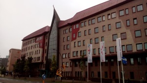
The faculty of ITC, Enschede |
But probably of utmost importance at this early stage in my research is
the contacts that have been made, and the opportunities that are now open to
me for follow-up questioning should it be required. Though I have hours and
hours of recorded interviews and pages and pages of transcripts, which is
all valuable information, the benefit of meeting people face-to-face cannot
be overlooked. At Kadaster I was also given the opportunity to give a short
presentation on the purpose of my visit and my research objectives.
While trying to set up interviews in Germany, Jens Riecken confessed to
me that my trip was awkwardly timed due to the Intergeo conference that
would be taking place in Berlin during the second week of October. But he
suggested that I try to go to the conference as I would be able to meet more
people there who could give me further information, and a significant part
of the conference itself was dedicated to ALKIS® and land administration in
general. So I took his advice and acquired additional funding to cover the
cost of conference fees and the extension of my stay overseas. But my time
at Apeldoorn ended a week before the conference, leaving me with a week to
fill. So I contacted Jaap Zevenbergen at ITC, Enschede, and asked if I could
visit his faculty during that week, and he graciously accepted.
The week spent at ITC was wonderful because it gave me a chance to
consolidate what I had learnt over the previous two weeks of interviews and
observations, in a quiet environment free of the usual distractions. I also
had an opportunity to meet and chat with several important researchers in
the land administration field: Paul van der Molen, Rohan Bennet, Walter de
Vries, and of course Jaap Zevenbergen. This was time well spent as I talked
through some of my ideas for my research and got feedback from them. I
reciprocated by giving a short presentation on some of the work that my
undergrad students have been doing at the University of Cape Town, involving
the application and critique of a model developed by a student of Rohan and
Jaap.
Other than the trauma of losing my passport in Berlin, offset by the
relief of finding it again (there’s a whole story there that I can’t go into
here!), I loved the city and the Intergeo conference. I was, admittedly,
very tired by this point and initially struggled to find the energy for more
networking. I was also very disappointed to learn (just before leaving South
Africa) that the vast majority of the conference was in the German language,
including the part on land administration that I had been looking forward to
(I don’t speak or understand German!). But I did manage to chat to some of
the software developers involved in the ALKIS® project and gained valuable
insights into the intricacies and difficulties associated with the project.
I also attended a very interesting plenary talk (in English) in which future
trends in geomatics were discussed. And of course I got to see all the
latest and greatest that technology has to offer the geomatics industry.
All in all it was a great experience from which I learnt a lot and made
valuable contacts and some new friendships. I feel that a solid foundation
has been laid from which I can continue building towards the completion of
my doctorate. I am immensely grateful to FIG and the South African Geomatics
Institute for providing the funding for this trip, and I look forward to
future collaboration in this regard. Unfortunately there hasn’t been
sufficient time for analysis between the completion of the research trip and
the submission date for abstracts for the FIG Working Week in Sofia, else I
would have liked to present something there. But I should be ready (with
even more data) for the next one …
Mr Simon Hull
Lecturer and PhD student
University of Cape Town
South Africa
18 November 2014
|


